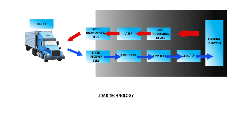
LIDAR (Light Detection and Ranging) communication systems are used for a variety of applications, including mapping, surveying, and autonomous vehicles. These systems use laser beams to measure distances, creating a high-resolution 3D map of the surrounding environment. The data collected by LIDAR systems is transmitted wirelessly to a processing unit for analysis. LIDAR communication systems are crucial for creating accurate and detailed maps, as well as for enabling autonomous vehicles to navigate and make decisions in real-time. In addition, LIDAR communication systems can also be used for environmental monitoring, including the measurement of atmospheric gases and the monitoring of wildlife populations. The use of LIDAR technology is increasing rapidly, and new applications are constantly being developed, making it an exciting and dynamic field with great potential for growth and innovation.
Parijat Controlware. Inc (PCI) LIDAR communication-based Systems
PCI is one of the major service provider that uses Light Detection and Ranging (LIDAR) technology. With their cutting-edge LIDAR communication systems, PCI is changing the way organizations collect and use data to make informed decisions.
LIDAR technology is a highly accurate remote sensing system that uses laser light to measure distances to objects. When combined with advanced communication technology, LIDAR systems can provide real-time data that can be used in a variety of applications, including mapping, robotics, autonomous vehicles, and more.
PCI LIDAR communication systems offer a range of benefits to organizations. For example, they provide highly accurate data in real-time, allowing organizations to make informed decisions quickly. They also offer a flexible and scalable solution, allowing organizations to easily adapt to changing needs and requirements. In addition, PCI LIDAR communication systems are designed for ease of use, with an intuitive user interface that makes it easy for even non-technical users to set up and manage their LIDAR systems. PCI also offer comprehensive support and maintenance services, ensuring that organizations receive the help they need to keep their LIDAR systems up and running. PCI is changing the way organizations use data to make informed decisions with their cutting-edge LIDAR communication systems. These systems offer a range of benefits, including highly accurate real-time data, flexible and scalable solutions, and ease of use.

PCI Offered LIDAR Based Systems Key Features
PCI offers LIDAR solutions with several key features. Here are some of them:
1. High Accuracy: PCI LIDAR systems provide highly accurate measurements of the environment with up to 5 mm accuracy.
2. Long Range: The systems can cover long distances, with a maximum range of up to 500 meters.
3. High Resolution: The LIDAR systems offer high resolution, providing up to 600,000 points per second.
4. Multiple Returns: The systems can capture multiple returns per pulse, enabling a more detailed understanding of the environment.
5. Scanning Speed: The systems can scan at high speeds, up to 100 scans per second, allowing for quick and efficient data collection.
6.Compact Design: PCI LIDAR systems are compact and lightweight, making them easy to transport and install.
7. User-Friendly Software: The company offers user-friendly software for data acquisition and processing, allowing for quick and easy analysis of the collected data.
8. Customizable Solutions: PCI can provide customized LIDAR solutions to meet specific project requirements, such as different wavelengths and laser power options.
PCI LIDAR systems offer high accuracy, long range, high resolution, multiple returns, high scanning speeds, and user-friendly software, making them a versatile solution for a wide range of applications, including mapping, surveying, and engineering.
Conclusion
PCI offered LIDAR communication-based systems provide cutting-edge technology for data acquisition and processing. With advanced features such as real-time data transfer, error detection, and easy-to-use interfaces, PCI LIDAR communication systems are the ideal solution for a wide range of applications, including autonomous vehicles, mapping, and surveying.


